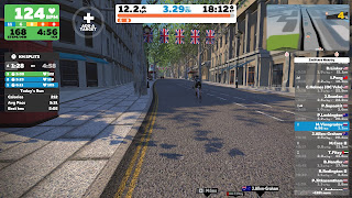
What is the problem with current online orienteering projects (based on Google Street view or CF/O-Virtual)? You are not running! It is more like a puzzle-solving. My idea is to use Zwift training with O-courses. Take a look at the video below:
I was running through the streets of London with O-map reading (London city race map, but I have prepared my own course) and navigation (left/right turns and U-turns). Instead of other online orienteering projects, you are physically running and the terrain view in front of you depends on your pace! Also, you may adjust the climb.
I was running through the streets of London with O-map reading (London city race map, but I have prepared my own course) and navigation (left/right turns and U-turns). Instead of other online orienteering projects, you are physically running and the terrain view in front of you depends on your pace! Also, you may adjust the climb.


They had something like that at WOC 2013 but never see anything like that since.
ReplyDeleteGood to know!
Delete